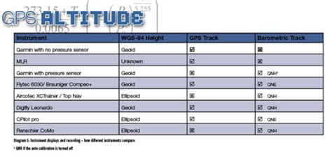
Altimeter Calibration Errors Barometric vs GPS Elevation Data
Introduction:
Altimeters are essential tools for measuring altitude, whether for recreational activities like hiking or for professional applications such as aviation and meteorology. However, one of the most common challenges faced by users is the discrepancy between barometric and GPS elevation data. This article aims to explore the sources of calibration errors in altimeters and the differences between barometric and GPS elevation data.

Barometric Altimeters:
Barometric altimeters, also known as aneroid altimeters, rely on the principle of atmospheric pressure to determine altitude. These devices contain a sealed, flexible container that expands or contracts with changes in atmospheric pressure. As the air pressure decreases with altitude, the container expands, causing a needle or digital display to indicate the altitude.
Barometric Altimeter Calibration Errors:
Several factors can contribute to calibration errors in barometric altimeters:
1. Temperature Variations: The accuracy of a barometric altimeter is highly dependent on temperature. As temperature changes, the air pressure changes, which can lead to inaccurate altitude readings.
2. Humidity: High humidity levels can also affect the accuracy of barometric altimeters. The air density is influenced by humidity, which can cause the altimeter to read higher or lower than the actual altitude.
3. Calibration Errors: Improper calibration or wear and tear on the device can result in inaccurate readings. It is essential to calibrate the altimeter regularly to ensure its accuracy.
GPS Elevation Data:
Global Positioning System (GPS) altimeters, on the other hand, use satellite signals to determine altitude. These devices measure the time it takes for a signal to travel from a satellite to the receiver and calculate the altitude based on the known distance between the satellite and the Earth’s surface.
GPS Elevation Data Accuracy:
GPS elevation data is generally considered more accurate than barometric altimeters, especially at higher altitudes. However, there are still some factors that can affect its accuracy:
1. Signal Interference: Obstructions such as buildings, mountains, or dense forests can interfere with satellite signals, leading to inaccurate elevation readings.
2. Multipath Errors: Multipath errors occur when the GPS signal reflects off a surface before reaching the receiver. This can cause the receiver to calculate an incorrect distance, resulting in a false altitude reading.
3. GPS Glitching: In some cases, GPS receivers may experience glitches, causing temporary loss of signal and inaccurate elevation data.
Comparing Barometric and GPS Elevation Data:
When comparing barometric and GPS elevation data, it is essential to consider the following:
1. Accuracy: GPS elevation data is generally more accurate than barometric altimeters, especially at higher altitudes. However, both devices can experience errors due to various factors.
2. Reliability: Barometric altimeters may be less reliable in areas with rapid changes in weather, such as storms or high winds, as these conditions can cause fluctuations in atmospheric pressure. GPS altimeters, on the other hand, are less affected by weather conditions.
3. Cost and Portability: Barometric altimeters are generally more affordable and portable than GPS altimeters. This makes them a popular choice for recreational activities.
Conclusion:
In conclusion, both barometric and GPS altimeters have their advantages and disadvantages. Understanding the sources of calibration errors and the differences between barometric and GPS elevation data can help users make informed decisions when choosing an altimeter for their specific needs. Regular calibration, proper usage, and awareness of potential errors can contribute to more accurate and reliable altitude measurements.