All-Terrain Navigation Smartwatch GPS vs Traditional Map Accuracy
In the ever-evolving world of technology, navigation has become more accessible than ever before. With the advent of smartwatches equipped with GPS, hikers, runners, and outdoor enthusiasts now have a plethora of options at their fingertips. However, the debate over the accuracy of GPS in all-terrain navigation smartwatches versus traditional maps remains a hot topic. This article aims to explore the strengths and weaknesses of both methods, helping you make an informed decision for your next outdoor adventure.
**All-Terrain Navigation Smartwatch GPS: The Modern Convenience**

Smartwatches with GPS have revolutionized the way we navigate outdoor terrains. These devices offer a range of features, including real-time tracking, distance measurement, and offline maps. Here are some advantages of using GPS in all-terrain navigation smartwatches:
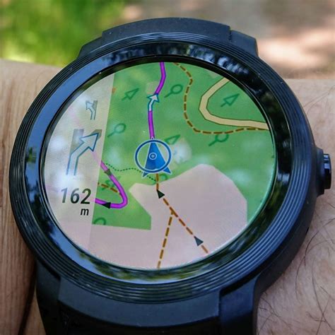
1. **Real-Time Tracking**: GPS smartwatches provide real-time tracking, allowing users to monitor their progress and stay on course. This feature is particularly useful for hikers and runners who want to ensure they reach their destination safely.
2. **Offline Maps**: Many smartwatches come with pre-installed offline maps, ensuring that you can navigate without an internet connection. This is beneficial in remote areas where signal strength may be weak.
3. **Customizable Profiles**: Users can customize their smartwatch profiles for different activities, such as hiking, cycling, or running. This allows for more accurate tracking and personalized data.
4. **Multi-Sport Compatibility**: GPS smartwatches are designed to cater to various outdoor activities, making them a versatile option for adventurers.
**Traditional Maps: The Classic Approach**
Traditional maps have been the go-to navigation tool for outdoor enthusiasts for centuries. While they may not offer the same level of convenience as GPS smartwatches, they have their own set of advantages:
1. **No Battery Concerns**: Unlike GPS smartwatches, traditional maps do not require batteries. This makes them an ideal choice for extended trips where you may not have access to charging facilities.
2. **Detailed Topography**: Maps often provide detailed topographical information, making it easier to identify natural landmarks and terrain features.
3. **Accurate Scale**: Traditional maps offer an accurate scale, allowing users to measure distances and plan their routes effectively.
4. **Customization**: You can mark important points, create custom routes, and even add annotations to traditional maps.
**The Verdict: GPS vs Traditional Maps**
The debate between GPS smartwatches and traditional maps in all-terrain navigation boils down to personal preference and the specific requirements of your outdoor activity. Here are some scenarios where each method excels:
– **GPS Smartwatches**: Ideal for real-time tracking, multi-sport activities, and areas with poor signal strength.
– **Traditional Maps**: Best suited for extended trips, detailed topographical information, and when battery life is a concern.
Ultimately, the choice between GPS smartwatches and traditional maps depends on your individual needs and preferences. Combining both methods can provide the best of both worlds, ensuring a safe and enjoyable outdoor experience.